Walk - Around The Village
This walk continues from the end of the Churchyard Walk
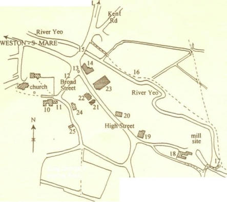
12.
Broad Street. The unusual width suggests it was a planned arrangement for the weekly market
and annual fair (granted in 1227 and lasting until this century). Fair day was the highlight of the year
when farmers bought and sold sheep and cattle. Horses were run back and forth to show off their
paces and hawkers and peddlers sold their wares. You could even get your teeth extracted in the
street! In July 1968 the river overflowed its banks and water in Broad Street covered the top of the
telephone box, which was by the trees.
13.
14th/15th century Market Cross - Congresbury's best known landmark and a meeting place for
several hundreds of years.
14.
The Ship and Castle. The sign on this mainly 18th century building is the coat of arms of Bristol
and in 1.658 the Inn was called the Bristol Arms. The sign is a reminder that, from the. end of the 16th
century until 1921, Bristol Corporation owned a large part of Congresbury. The rents and profits from
the manor were used to support Queen Elizabeth Hospital in Bristol.
15.
Congresbury Bridge. Both the course of the river and the bridge were moved further from the
Ship and Castle in 1924 when the bridge replaced at least two earlier structures.
16.
The River Walk. The first field you enter is Congresbury's Millennium Green which is linked, with
a bridge, to more land on the south side of the river. Looking north from here you can see Cadbury Hill,
where there is an important Iron Age and post Roman hill fort.
17.
The Weir which for several centuries was called "Tumbling Weir." Close by is the site of one of
Congresbury's mill sites (possibly one of the two mentioned in Domesday Book), although little now
remains except the millpond. Surprisingly Congresbury was part of the iron industry, from c1725 to
c1750, when this mill was used to turn iron bars into rods for nail making.
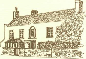
18.
The Birches is an elegant early 18th century Georgian house. Trees inhibit the view of the house
during the summer.
19.
The Plough, another of Congresbury's many pubs. The name reflects that this was once a
smallholding.
20.
Yeo Meads. A house is shown in this position on the parish map of 1739. At the rear is a 300 year
old Cedar of Lebanon suggesting that part of the house at least existed at the end of the 17th century.
21.
The Methodist Chapel was constructed in 1878 to seat 150 people. The porch is a recent addition.
22.
The Old Rectory. This is probably an early 17th century building "modernised" in the 18th century
with the addition of a Georgian facade.
23.
The War Memorial Hall, constructed in 1920, commemorates Congresbury men and women who
served and died in the two World Wars.
24.
The Old Inn. The building possibly dates back to the 16th century but there is no evidence to
suggest it was a pub until much later. The cottages to the left of the Old Inn were all built after 1739 with
the nearest built in 1996!
25.
Appleton House, another house shown on the 1739 map.
CONGRESBURY HISTORY GROUP